Ottawa Weather Alert: Dangerous Tuesday Storms Bring Tornado Risk West of the City
A serious Ottawa weather alert has raised concern across eastern Ontario as strong thunderstorms and a possible tornado risk threatened areas west of the capital on Tuesday. Communities including Bancroft, Kaladar, Pembroke, and nearby regions were placed under close watch as forecasters warned that fast-moving storms could bring damaging winds, large hail, heavy rain, lightning, and isolated tornadic activity.
Environment Canada issued a severe thunderstorm watch for communities west of Ottawa on Tuesday afternoon and evening, with forecasters warning that the storm system had the potential to produce strong winds and possibly a tornado.
Severe Weather Threat Builds West of Ottawa
The storm risk developed as unstable air moved across parts of southern and eastern Ontario. While Ottawa itself was not necessarily the centre of the highest risk, the threat west of the city was significant enough to trigger concern for residents, drivers, outdoor workers, and anyone with evening travel plans.
The biggest concern was the possibility of powerful thunderstorms capable of intensifying quickly. Severe thunderstorms can develop with little warning, especially when warm, humid air interacts with a cold front or shifting wind patterns. In this case, the storm threat included strong wind gusts, heavy downpours, hail, and a low but serious tornado risk.
For residents in rural areas west of Ottawa, the warning carried added importance. Open roads, farmland, wooded areas, and smaller communities can be especially vulnerable when damaging winds move through quickly.
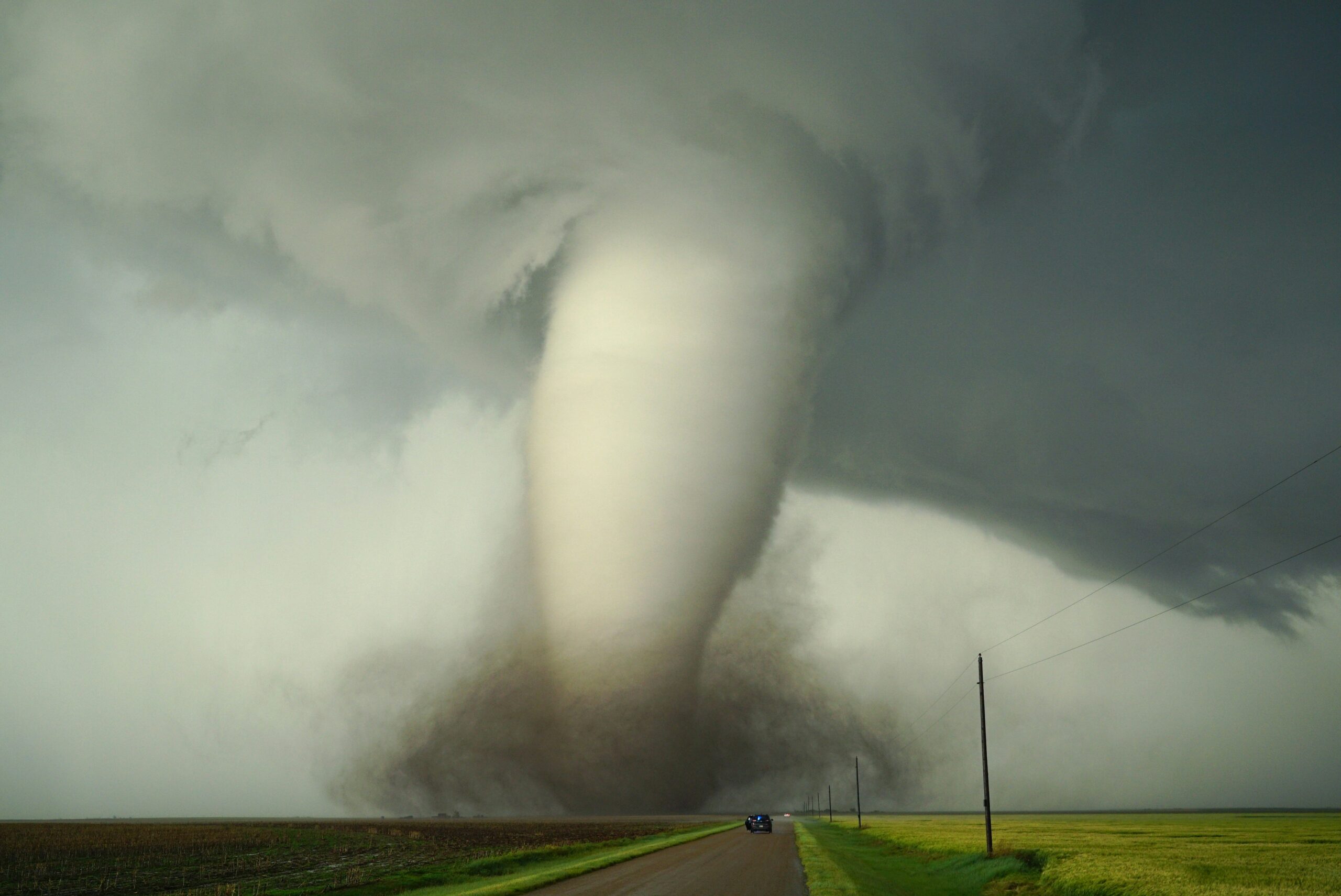
Tornado Risk Raises Safety Concerns
Although tornadoes remain relatively uncommon compared with regular thunderstorms, even a small tornado risk must be taken seriously. Tornado-producing storms can form rapidly and may be difficult to track at the local level until rotation becomes more organized.
Environment and Climate Change Canada notes that severe weather during the warm season can include thunderstorms, tornadoes, hail, damaging winds, heavy rain, and lightning. The agency also says Ontario and Quebec average about 17 tornadoes each year, with peak tornado season running from June through August.
This makes late spring and summer an important period for weather awareness in eastern Ontario. A storm does not need to produce a confirmed tornado to cause damage. Straight-line winds from severe thunderstorms can knock down trees, damage roofs, disrupt power lines, and create dangerous driving conditions.
Strong Winds, Hail, and Lightning Also Possible
Along with the tornado concern, strong thunderstorms west of Ottawa carried several other hazards. Damaging wind gusts can bring down tree branches and power lines, while hail can damage vehicles, crops, gardens, roofs, and outdoor equipment.
Lightning also remains one of the most dangerous parts of any thunderstorm. Environment Canada advises that if thunder can be heard, people are close enough to be struck by lightning and should move indoors. The agency recommends staying inside for 30 minutes after the last rumble of thunder.
Heavy rain can also create sudden visibility problems on highways and rural roads. Drivers travelling between Ottawa, Pembroke, Bancroft, Kaladar, and surrounding communities were advised to remain alert for rapidly changing conditions.
Areas West of Ottawa Should Stay Weather-Aware
The communities most closely watched included areas west and southwest of Ottawa, where severe thunderstorm conditions were expected to be more favourable. Residents in these regions were encouraged to monitor official alerts, check radar updates, and be ready to move indoors if skies darkened or thunder developed.
Outdoor plans, school activities, construction work, farming operations, and evening travel could all be affected by the storm threat. People living in mobile homes, cottages, or rural properties should be especially prepared because these structures can be more vulnerable during high winds or tornadic storms.
What Residents Should Do During Severe Storms
Anyone under a severe thunderstorm watch or warning should take practical safety steps before the storm arrives. Secure loose outdoor items such as patio furniture, bins, garden tools, trampolines, and temporary structures. Park vehicles away from trees if possible. Charge phones and keep flashlights ready in case of a power outage.
If a tornado warning is issued, residents should move immediately to a basement or an interior room on the lowest level of a sturdy building. Stay away from windows, doors, and exterior walls. If driving, avoid stopping under bridges or overpasses and seek a safe indoor shelter if possible.
People should also avoid flooded roads. Even shallow-looking water can hide road damage or strong currents, and driving through flooded areas can quickly become dangerous.
Ottawa Residents Should Not Ignore Nearby Storm Risk
Even if the strongest storms remain west of Ottawa, residents in the capital should still stay informed. Severe weather systems can shift, weaken, strengthen, or change direction depending on local conditions. A storm that begins outside the city can still affect traffic, power supply, evening events, and surrounding commuter routes.
The Government of Canada’s weather alert system provides active alert information by province and forecast location, allowing residents to check updated warnings and watches as conditions change.
Also Read About: Ottawa Boating Season Begins Strong Despite Costly Fuel Price Surge